
(Cue music ) Alan Jackson, It's Five O'Clock Somewhere, "The sun is hot and that old clock is movin' slow. And so am I"
They say that timing is everything
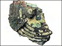
Today's science columns are awash with the news that a team of scientists and engineers has "decoded" the object known as the "Antikythera Device".
"Writing in Nature, the team says that the mechanism was 'technically more complex than any known device for at least a millennium afterwards'."
Ever since its discovery in 1900, the device has spawned speculation as to its real purpose. Now, an article in Nature declares it was used in part, at least, to predict eclipses. This is a left handed admission that the ancients understood orbital mechanics far better than had previously been credited to them. The moon's eliptical orbit means that eclipes, while periodic, are not annual. So a simple calendrical device can not predict them accurately. The device has a specially offset gear mechanism that incorporates the moon's eliptical orbit. This is a practical device from about 150 bce that employs the orbital mechanics and calculus that history tells us wasn't invented until after Sir Isaac Newton got thumped on the head by a falling apple in the seventeenth century AD.
From BBC
"When you see it your jaw just drops and you think: 'bloody hell, that's clever'. It's a brilliant technical design," said Professor Mike Edmunds.
Planetary display
The team was also able to decipher more of the text on the mechanism, doubling the amount of text that can now be read.
"Combined with analysis of the dials, the inscriptions hint at the possibility that the Antikythera Mechanism could have also displayed planetary motions.

"Inscriptions mention the word 'Venus' and the word 'stationary' which would tend to suggest that it was looking at retrogressions of planets," said Professor Edmunds.
"In my own view, it probably displayed Venus and Mercury, but some people suggest it may display many other planets."
One of those people is Michael Wright. His reconstruction of the device, with 72 gears, suggests it may have been an orrery that displayed the motions of the five known planets of the time.
"There is a feature on the front plate that could have made provision for a bearing with a spindle, that carried motion up to a mechanism used to model the planets of Mars, Jupiter and Saturn as well," he told the BBC News website.
"That's how I see it and my reconstruction shows it works well."
Intriguingly, Mr Wright also believes the device was not a one-off.
"The designer and maker of the device knew what they wanted to achieve and they did it expertly; they made no mistakes," he said.
"To do this, it can't have been very far from their everyday stock work."
The team speculates that the gear works was housed in a shoebox-sized wooden case and that the hinged lids or covers would have been illustrated with detailed instructions for the device's use. In other words, the making of this device was not some single use experiment, but was likely a "standard issue" part of ancient navigation and or astronomy. It was found with the wreck of a cargo ship, not some war galley or ship of exploration.It was also built two centuries or so after Archemedes first committed to script his early mathematical treatises on:- Equilibrium of Planes
- Spiral Lines
- The Measurement of the Circle
- Sphere and Cylinder
- On Floating Bodies
- The Method of Mechanical Theorems
- Stomachion
The Archemedes connection goes quite a bit farther than that, however. He was a Grecian-born patriot of Carthage at a time when Carthagenian maritime society was at war with ancient Rome, a national and political affiliation that eventually led to his demise at the hands of a Roman soldier. That is a tale worthy of its own telling, but, again, I will save it for another post. Pursuant to this discussion, Archemedes was both a master of mathematical theory for his day and he was a third century BC analog of Thomas A. Edison, inventing or developing practical solutions to everyday needs.
Back to the device and its origins. About the same time it was built, another Greek, Hipparchus, was publishing his catalog of a thousand stars visible from Greece and throughout the Mediteranian.
From space.com
"Hipparchus, who was Greek, was one of the greatest of the ancient astronomers and did his most important work between 140-125 BC. He calculated the length of the year to within six and a half minutes, developed a scale to rate the brightness of stars, was the first to record a nova, theorized on the motions of the Sun and Moon, provided high quality planetary observations and created the first ever catalog of 1,000 stars."
Hipparchus wasn't the first to compile such a star catalog, but his accuracy and scope was uncanny for a time when scholars believe there were no sophisticated instruments. The earliest extant star catalog was the work of an anonymous Assyrian in 1130 BC. The accuracy of Hipparchus' version is within 3.5 degrees. According to the latest findings, Hipparchus' work is actually slightly younger than the Antikythera device by a decade or so, but, and I'm speculating here, could have been related to researching a new and improved version. He worked in a time that histroy tells us he could not have used any sophisticated angular measurement or optical instruments. Yet, it seems to me that the Antikythera device is pretty darned sophisticated. He also probably had access to all of Archemedes' work. Then, as today, all "new" science grew from previous work.
Away from the Greeks for the moment and on to a much simpler device: No gears, no long list of instructions, no extensive star catalogs, and no math. In other words, something that an illiterate sailor could master.
Thanks to the work of Myron Paine, and with his permission, let me expound on one of the simplest navigational devices from antiquity, the Ki Mal.

The KIMAL
Myron Paine
In 1810 a “pendant” was found in Nova Scotia. A digital photo of that “pendant” is shown in the picture to the right with a simulated night scene in the background.
During the summer of 2005, the Museum of Modern art in Ottawa, Canada displayed about a dozen cruder versions “pendants” used by the Inuits. All “pendants” had the three-pronged base.
Were the “pendants” used to determine latitude?
The Arabs called similar devices "Al Kemal." The Vikings may have called their device simply a "Ki mal.,” meaning “peek picture.” The Kimal shown appears to be more precise and versatile than the Al-Kemal, which could only determine one preset latitude. (Slaughter, 1957)
The height of the North Star above the horizon varies with the latitude of the viewer. To measure the North Star’s height the viewer may have held a Kimal tethered to his head by two necklaces, which established a set distance from his eyeball. The angle seen from the eye to the Kimal is the same angle as from the eye to the distant horizon and the North Star.
The viewer may have rapidly scanned along the horizon until he saw the North Star in the slit. Then he may have lowered the Kimal until the North Star peeped through the hole. He may have moved a slender needle onto the notches until the needle looked as if it was on the horizon, which could be seen behind the Kimal. Then he may have clamped the needle with his thumb. While holding the needle in place, he may have moved to a fire to make an accurate count of the notches.
One necklace was secured to the top of the Kimal. During the day, the Kimal may have hung around the viewer’s neck.
A second necklace may have just hung loose around the neck. When the Kimal was being used, the second necklace was slipped up around the center prong of the three-pronged base. The two necklaces may have been tied together at a point determined by stretching the necklaces away from the Kimal. The knot may have been slipped over the viewer’s head to hold the Kimal at a set distance from his eye.
This Kimal was calibrated by adjusting the necklaces so that the distance from the star hole to the bottom of the solid crosspiece was the same as the distance as from the Kimal to the eyeball. Known measurements on the ship's deck and main spar may have created an equal sided triangle to verify that the Kimal was in calibration for 45 degrees latitude. The exact latitude, in degrees, was not always needed. The correct notch required to sail at a given latitude was easier to remember and simpler to determine.
The Kimal illustrated to the left indicates that the ship is south of 45 degrees latitude. The Captain will adjust course to the north. By taking repeated measurements with the Kimal, the ship will eventually arrive within 15 miles, north or south, of Nova Scotia.
The ancient, but real, pendant is now in the British Museum and is shown in the Beothuk chapter of the Handbook of North American Indians, Vol. 15, p. 104, fig. 5, left.
---------------------------
After reveiwing Myron's analysis of this object, I can find no fault with his logic as he stated the use. However, I think there may be more to this ultra-simplistic latitude measurement device. The graduations that are etched into the edges of the grooves and the "splay" angle of the legs may serve a more utilitarian purpose, not be mere decoration. Over the coming weeks, I hope to make a reproduction of this device and conduct some experiments to see if it could also be used for crude longitude measurment.
Okay, that's a lengthy discussion of only two devices of the several (perhaps, many) used for navigation in antiquity, and still no maps, records of discovery, or hard evidence of pre-Columbian visitation. Partly because the "news worthiness" and timliness of the Antikythera device warranted that I devote most of this post to it. I promise to get back to Pytheas' sponsors and the maps (and Archemedes) in the next one.
Holy invisible ink, Batman!! What happened to the message?Tune in next time to the Oopa Loopa Cafe


No comments:
Post a Comment