Monday, March 19, 2007

Flight of the Navigator Part VI

Cue music: Dem Bones

Toe bone connected to the foot bone
Foot bone connected to the leg bone
Leg bone connected to the knee bone..
From Wikipedia

Dem Bones or Dry Bones or Dem Dry Bones is a well-known traditional spiritual, often used to teach basic anatomy to children (although its description is far from anatomically correct). The melody was written by James Weldon Johnson [1]. Two versions of this traditional song are widely used, the second an abridgement of the first. The lyrics are based on Ezekiel 37:14, where the prophet visits the Valley of Dry Bones[1] and brings them to life by mentioning God's name.


Sticks and stones

In the previous installment, I listed several classes of evidence that suggest very strongly that cultural exchange, commerce, and genetic material crossed the oceans long before Columbus did. One of the classes I mentioned was skeletal. Funny thing about bones, a forensic pathologist or forensic anthropologist can discern many things about dead people's bones, including what ethnicity the living person was.

Enter Kennewick Man, The Power of First Impressions

James C. Chatters was the first person to conduct a scientific examination of the skeletal remains that became known as Kennewick Man. The following is quoted from the web page at the Smithsonian Institute linked at Mr. Chatters' name

"Discovery

"On July 28, 1996 two young men encountered a human skull in the Columbia River at Kennewick, Washington. That evening I was contacted by Coroner Floyd Johnson, for whom I conduct skeletal forensics. I joined him at the site and helped police recover much of the skeleton. During the next month, under an ARPA permit issued by the Walla Walla District Corps of Engineers, I recovered more wave-scattered bones from the reservoir mud. Throughout the process, I maintained contact with the Corps, which interacted with two local Indian Tribes.


"The completeness and unusually good condition of the skeleton, presence of caucasoid traits, lack of definitive Native-American characteristics, and the association with an early homestead led me to suspect that the bones represented a European settler."


That first impression was most likely correct. Kennewick Man probably was what Mr. Chatters surmised, but several millenia before there should have been a white European along the Columbia River.

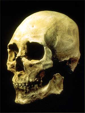
What first tipped off James Chatters to the skull's possible European traits was how the nose projected. As the forensic anthropologist looked closer, he found other clues: how the face itself projected between the eyes and upper lip and how narrow the face was; the delicate lower jaw; the long, narrow cranium; and the absence of flaring cheekbones. Photograph by James Chatters/Applied Paleoscience.


Healed Over

A leaf shaped projectile point was detected embedded in the pelvis of Kennewick Man's skeleton. This was Mr. Chatters' first clue that the skeleton in question was not a settler in historic times. Calcification around the projectile indicated that it was not the wound that killed KM, but it certainly was evidence that KM was probably much older than the historic settler era of that region of Washington. The projectile design and manufacture was common and consistent to those found in the Columbia River basin.
"I first began to question this when I detected a gray object partially healed within the right ilium. CT scans revealed the 20 by 54 mm base of a leaf-shaped, serrated Cascade projectile point typical of Southern Plateau assemblages from 8500 B.P. to 4500 B.P. However, similar styles were in use elsewhere in western North America and Australia into the nineteenth century."

Then the story of KM starts getting weird. Perhaps even a little bit sinister. Remember, Chatters was in regular communications to the coroner, through him to the Army Corps of Engineers, and through them to the tribes.

"We either had an ancient individual with physical characteristics unlike later native peoples' or a trapper/explorer who'd had difficulties with "stone-age" peoples during his travels. To resolve this issue, the Coroner ordered radiocarbon and DNA analyses."

That's when the remains became controversial. The radiocarbon dating showed that KM died 8410 +/- 60 B.P (conducted late summer 1996). With that age of the bones verified by accepted dating techniques, how could KM have been anything other than a native American and thus subject to the Native American Graves Protection and Repatriation Act of 1990 (NAGPRA)?

Without reiterating all the gory details of that dogfight, multiple lawsuits ensued about who would have custody of those remains. Would KM be reburied by one of the tribes, be studied by scientists, or even be honored as a European ancestor by American Pagan groups?

The Federal Government pulled out all stops to get the bones into the hands of the tribes for reburial in a secret location that would halt all further efforts that might result in KM being proven anything other than a Native American, all under the auspices of NAGPRA.

Scott L Malcomson wrote a brilliantly insightful and in-depth article for the New York Times as to why it was important for the government to pursue that course of action and he interviewed the other interested parties (no interviews with government officials were granted). It boils down to racial issues and related laws. Mr. Malcomson also acquired a new appreciation for the natural beauty of both that part of the country and of the people who live there. As did I, just by reading his article.

As to Mr. Chatters, he has become somewhat resentful of some of the attention. Before the discovery of KM, he enjoyed a truly good, friendly relationship with the tribes in that area (where he lives and whom his business supports). Since the discovery, some tribe members are cool towards him and his work. He misses them as friends, but he stands by that first impression that KM does not have the skeletal features usually attributed to Native Americans.

James Chatters: The forensic anthropologist who sparked the controversy. Photograph by Eve Fowler for The New York Times.


Patrick Stewart Face

Jim Chatters also undertook a reconstruction of KM's face using accepted techniques. You can find a Quicktime (c) 3D view here.


The DNA


And then there is the DNA evidence. Or rather, the lack of it. Examination of the reports of this testing seem to indicate that no matter how many times they repeated the test, the results were unacceptable -- always showing caucasoid origins. So they blamed it on contamination of the tools by one or more of the investigators. These reports are, of course, prepared by the agencies of the Federal Government.

In reality, contamination of samples is a very real problem in the type of DNA testing used. The replication of sequencing tends to "grab" any foreign genetic material and replicate it in the billions while doing the same for the test sample. It's just the nature of the process.

However, in reading those reports, and in my related research regarding lab techniques as reported, it seems these were very careful, professional people conducting these tests. The whole contamination issue seems very reminiscent of the arguments involved in the so-called "cocaine mummies", and those arguments still sound lame to me for both cases.

Why all the hubbub, Bub?

As Mr. Malcomson so aptly stated it, if KM is caucasian (or anything other than American Indian), then the implications affect many current social, cultural, and legal points and ultimately upsets the status quo. KM's ethnicity can even throw into question the validity of current recognition of tribal rights and national legal status.

Furthermore, KM as Caucasian upsets all the archeaological, historical, anthropological, and even "right of discovery" applecarts.

Even among the more adventurous scientists in the field, the consensus is holding, for now, that all or most pre-Columbian Americans came from northern Asia and, at the outside, Southeast Asia. However, the public imagination, and to a degree the scientific imagination, has tended to fasten on the possibility of ancient Europeans reaching America prior to the ancestors of Native Americans. Within the scientific literature, ancient European migration is in a contest with African migration for last place. Nevertheless, when the lead plaintiff in the scientists' lawsuit, Robson Bonnichsen, tried to explain in a court affidavit why Kennewick Man deserved careful study, he said current science suggests "that the earliest inhabitants of this continent may have no modern descendants. . . . Multiple colonizing groups appear to be represented and many of the oldest studied skeletons have strong Caucasian skeletal features."

That's a lawyer explaining to a judge on behalf of a bunch of scientists what all us lay diffusion people knew all along. He uses virtually the same language that Dr. Myron Paine uses to describe his "Many Model"; Many peoples, at many times, from many places. And his arguments were successful. KM is now an object of scientific study rather than filling an unmarked grave. Stay tuned. This story won't end here. The best we can hope for is that KM gets the respect and attention that the scientific community payed towards "Otzi", the 5,000 year old "iceman" discovered in the Alps. From the point of view of forensics, the two sets of remains had suffered arguably similar physical injuries. Otzi, however, never suffered the same indignities.

Dr. Paine will be my guest on the radio show on March 29th

=================================================

Links to the latest shows on the Oopa Loopa Cafe on blogtalkradio.com,

Interveiw w/ Fred Rydholm of AAAPF

Visit w/ Judy Johnson of AAAPF


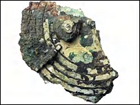
Ancient Navigation Tools
w/ William Smith or THOR group


What the Heck is an Oopa Loopa Cafe?


===================================

Spring Equinox!! But it's too cloudy here for me to do any sightings...

++++++++++++++++++++++++++++++++++++++++++++++++++++++++

Holy Stone Soup, Batman!! Who are all these big rocks telling us?

Tune in next time to here that message.

Monday, February 26, 2007

Flight of the Navigator, Part V

Cue music: Pink Floyd, Dark Side of the Moon, 'Money'
"Grab that cash with both hands and make a stash."


I closed the last post with "
Holy signposts, Batman, how will we know they were here?"

There are a considerable number of whole classes of evidence that might serve as those signposts:
  • Dolmens
  • DNA
  • Fortresses, harbors, or other structures
  • OOPAs, particularly those found in or around mounds, caves, mines, or mine tailings
  • Epigraphic or pictographic evidence
  • Lithic, bronze or iron works and items of old World styles in New World
  • Skeletal remains
  • Lingual evidence
  • Clothing, arms, armor, fabrics or furs unique to the Old World found in New World or vice verse
  • OOP animals
  • OOP Coins
For this installment, I want to concentrate on the latter: Ancient Old World coins found in the Americas. The late Gloria Farley was a prolific and careful researcher who cataloged several OOPAs during her career. Her book In Plain Sight is very highly recommended reading. Gloria wrote,

"The problem of the provenance of ancient coins can be summarized in one paragraph of a letter I wrote to Tom Lee, an anthropologist in Quebec:

'I agree with you that it is too bad that ancient coins are found by treasure hunters and amateurs (and housewives and children and chickens) instead of by scholars, but who else is going to find them? If they are authentic, they just are where they are, and found by accident. It is not at all logical to think that a professional archaeologist or anthropologist or numismatist or historian could set out to find one and succeed. Where in God's millions of square miles would he pick to hunt? And if by chance he did find one, then who would say he did not plant it?' "

Gloria and her research partners cataloged at least seven OOPA Carthaginian coins, several other Mediterranean coins of similar age, and Norse coins, all found from Maine to Nebraska. Other researchers have tallied no less than forty such ancient coins (Epstein).

Other OOPA or anomalous coin finds abound along the river systems of the eastern United States. Many of these were found in comparatively excellent condition. What would most people do if they found an ancient, out of place coin? Most people finding themselves in this position would go to the State Archaeologist, and, under general interpretation of current law, one must.

Such a find occurred near the Falls of the Ohio during construction of the Interstate 64 bridge in 1963. Only this wasn't just one out of place coin, it was a horde of coins!

Two of the coins from this cache were donated to the Museum of the Falls of the Ohio. Troy McCormick, former manager of the museum, put the coins on display.


Image credit: Troy McCormick

"For several years, the Falls of the Ohio Museum had an exhibit about the find that displayed several casts of both sides of the two originals, so as to reflect the approximate number of coins originally in the hoard. The two original coins, depicted above, are in storage and were not on public display. McCormick has informed me that the exhibit has recently been removed from public display, because the Museum belongs to the state of Indiana, and the exhibit conflicted with the state's archaeological policy that there is no documented evidence of pre-Columbian contacts."
In other words, following the intent of the law will get you no satisfaction should you come across any out of place artifact that would be evidence of pre-Columbian contact and take it to your State's archaeologist. Digging up native American pottery is a felony (UNLESS you are that State archaeologist). Digging up Old World coins is not policy.

So, does the presence of 3rd and 4th century AD Roman coins in southern Indiana clearly indicate that the Romans were here? Well, no. Although the coins were clearly of Roman origin, they could have been in the possession of peoples from anywhere in Europe, North Africa, the British Isles, all the way to India. Given the other pre-Columbian evidence in the same area, and putting it all into context, it seems very likely to me that peoples from the British Isles found their way to the Falls of the Ohio in ancient times, perhaps more than once.

More conventional scholars would brush aside such evidence and conclusions because the Romans left us no historical records of such excursions. There is a simple explanation for that: The Romans were kept out of that loop. Rome ruled from afar. Even the taxation or tribute was generally collected through native officials, messengers, and intermediaries. The Roman leaders often maintained spies within their government, but were often woefully unaware of what was happening in the far-flung territories. And the histories were written around the Roman government with mention of the territories only when the leaders went there or sent representatives. The historians (much as today) concentrated on the affairs of state, not the affairs of man.

I picked up two of the new Washington one dollar coins at the bank the other day. I think I'm going to "lose" one of them under a rock (with the help of a friend of mine) in northern Norway, just to throw a ringer into future archeology...


--------------------------------------------------------------------------------------------------------------

The Oopa Loopa Cafe on blogtalkradio this week featured William Smith of the THOR (The Hunters Ohio Rock) group. He reviewed the work of the group on the "rock" and other artifacts the group investigates.

Listen to the archive here

Visit the THOR site here

Holy boneyards, Batman! Who was this guy?

Thursday, February 15, 2007

Flight of the Navigator, Part IV


And now back to our somewhat irregularly scheduled programming.

Cue music:
Procol Harum
"We skipped the light fandango, turned cartwheels 'cross the floor,"

Wheels...

The circumference of a circle is the basis of many forms of measurement of both time and distance (and, as a byproduct, speed). The odometer and speedometer in a vehicle use it. Navigators and cartographers use it, too. So do engineers, architects, and rocket scientists.

So did the ancients.

More Archemedes
(from Wikipedia)

Archimedes exceeded any other European mathematician prior to the European Renaissance. In a civilization with an awkward numeral system and a language in which "a myriad" (literally "ten thousand") meant "infinity", he invented a positional numeral system and used it to write numbers up to 1064. He devised a heuristic method based on statistics to do private calculations that we would classify today as integral calculus, but then presented rigorous geometric proofs for his results. To what extent he actually had a correct version of integral calculus is debatable. He proved that the ratio of a circle's circumference to its diameter is the same as the ratio of the circle's area to the square of the radius. He did not call this ratio pi but he gave a procedure to approximate it to arbitrary accuracy and gave an approximation of it as between 3 + 10/71 (approximately 3.1408) and 3 + 1/7 (approximately 3.1429).

Apart from general physics, he was also an astronomer, and Cicero writes that the Roman consul Marcellus brought two devices back to Rome from the ransacked city of Syracuse. One device mapped the sky on a sphere and the other predicted the motions of the sun and the moon and the planets (i.e., an orrery). He credits Thales and Eudoxus for constructing these devices. For some time this was assumed to be a legend of doubtful nature, but the discovery of the Antikythera mechanism has changed the view of this issue, and it is indeed probable that Archimedes possessed and constructed such devices. Pappus of Alexandria writes that Archimedes had written a practical book on the construction of such spheres entitled On Sphere-Making.

Archimedes's works were not widely recognized, even in antiquity. He and his contemporaries probably constitute the peak of Greek mathematical rigour. During the Middle Ages the mathematicians who could understand Archimedes's work were few and far between. Many of his works were lost when the library of Alexandria was burnt (twice) and survived only in Latin or Arabic translations. As a result, his mechanical method was lost until around 1900, after the arithmetization of analysis had been carried out successfully. We can only speculate about the effect that the "method" would have had on the development of calculus had it been known in the 16th to the 17th centuries.


In other words, Archemedes understood the motions of celestial bodies (having learned from his father) and invented his own math to describe it. A feat unmatched until Newton the better part of two millennia later. But more to the point, Archemedes also developed instruments that other, simpler minded folks could use to predict those motions.


Also germane to this discussion, Archemedes was a contributing and respected member of the royal house of the greatest maritime power of that period in antiquity, Carthage. He designed ships, too. One of his designs that was actually commissioned, built and sailed, the Syracusia, was the largest ship seen on the Med in antiquity, dwarfing all others by several to one. One tale has it that Archemedes' screw (a type of water pump) was developed to remove bilge water from this immense vessel. However, Archemedes received his education at Alexandria and he referred to the device as the "Egyptian screw", so one may speculate that he didn't invent it at all, but merely adapted it to a different use, having seen it in use for irrigation in Egypt.

So there we have one man who had a background in astronomy, shipbuilding, instrument making, had travelled much of the then known world, developed calculus from scratch, and had the resources of one of the major ruling houses of antiquity. Is it such a stretch to speculate that he could have adapted his astronomical instruments to maritime navigation?

On to slightly less esoteric navigation / surveying aids:
Dividers
Squares
Plumb bobs

Two out of those three are the basis of the most common symbol of Freemasonry.


Cue music:

O that old rugged cross, so despised by the world,
Has a wondrous attraction for me

--
The Old Rugged Cross," one of the world's best loved hymns, was composed in Albion, Michigan in 1912 by the Reverend George Bennard (1873-1958)


Adding to the list

Last time I talked about the "Antikythera Device" and the Kimal. This time I want to discuss more devices, the Celtic or "wheel" cross and the "Coba" device (not to be confused with Cabo Wabo), and the gold chain.

The Celtic cross has been examined off and on for many decades as to possible meanings beyond Christian burial markers. Some very in-depth research was conducted by Crichton Miller. Adaptations and transmutations of the original meanings have become symbols for various groups and political activists, but Mr. Miller has concentrated on the ancient meanings and has hypothesized a purpose of the device, as a practical navigational tool. His case was compelling enough to win a British patent on his claim for a simple wheeled cross to act as a tool for navigation with an accuracy of 3 arc minutes of longitude.

The patent does not prove that the ancients used this tool or some form of it to navigate the high seas, but it does prove that they could have. For the "how it works" details, please see Crichton's website.

No slight to Crichton or anybody, but most other folks in the British Isles have stumbled around these things for some 1200 or 1300 years and never made that connection definitively. Though several others speculated that it might somehow be related to measuring angles, only Crichton, to my knowledge, has proven it as a practical device and supported the claim.


Another person who has devoted much time, travel, and effort in researching evidence of ancient navigation is William "Mark" Smith from south western Ohio. He and his Yahoo group, THOR, of which I am a member, have investigated and continue to investigate various ancient artifacts and discuss the possible use in navigation or mapping. Mr. Smith is a retired engineer in the automotive industry and applies a lifetime of engineering tools and skills towards these riddles. Several "classes" of artifacts have been identified as probable navigation aids. The one I want to spotlight here is the "Coba device" and how William (and I)
interpreted it.


But first, a little background on the actual artifact: The actual inscribed stone panels with the depiction of the "device", found near Coba, Mexico in the late twenties or early thirties disappeared in Germany during or shortly after the second World War. All we have to go on is one black and white photograph. From that, William built a model and tested it. It works.

I will let William explain it and other devices in greater detail during the Blogtalkradio Oopa Loopa Cafe program coming up on March 1st.

The last device I want to describe in this post is the chain. More specifically, the engineer's chain. Although nowadays, engineers' apulets depict gears, they once were represented by a chain (somewhat similar to the emblem of the International Order of Odd Fellows). Also, the "chief engineer" is called the "cheng" in print, but it is most often pronounced "chain". Some in the engine room might sometimes refer to that officer as "ball and chain", but not the good engineers.

Naval traditions die hardest. Why would the engineer be identified by a chain? Because sighting through the links of a chain is a quick, reliable means of measuring lunar distances. The link diameter is matched to the diameter of the moon when the chain is held at arms length. The engineer centers one link on the moon, slides the other hand to hold a different link in line with the other celestial body chosen for that sighting, then merely counts the links. Comparing this distance against the almanac allows the engineer to calculate the angular displacement (longitude) from the prime meridian. It also enables derivation of local time (Luna as chronometer).

I can't direct you to any website that discusses this application of chains as navigation aids because I haven't set one up and I don't think anybody else has considered this. However, an example of lunar distances measurement using cell phone cams then counting pixels can be found by registering at starpath.com. If you do that, you can see the basis of my hypothesis regarding engineers' chains.

Last item for this post

February 22, this coming Thursday, at 6 Central, will mark the first podcast of Oopa Loopa Cafe on blogtalkradio.com.

This call-in talk show centers on the evidence supporting
pre-Columbian contact, ancient technologies and sciences, and diffusion.
This show and will feature scheduled guests with predefined subject
matter and a family listening environment. It will be a companion to the
http://oopa-loopa-cafe.blogspot.com/ written blog -- where I intend to
recap shows. Also, all the shows will be archived for later listening.

The first show will "air" on 22 Feb. '07 at 7 pm Eastern, 6 Central.
CORRECTION: 02/21/07 8PM
Got a call from the nice folks at blogtalkradio.com this evening. They requested and I agreed to move back tomorrow's show one hour. So now it starts at 8 eastern, 7 central. So far, the March 1st and subsequent shows are still scheduled for 7 eastern and 6 central. If any of this changes, I will post again.

Oz

Find it at

http://tinyurl.com/2k8ng3

or go to

http://blogtalkradio.com/

type "Oopa" in the search box and it will take you to my host page.
Scroll down to the show description for segment details. The call in
number is near the top of the page for guests and listeners to call in.
When the show is on live, there is an icon next to the segment description
("Listen Live" or similar). Afterwards, listeners can click on the
archived shows, but there are none yet.


Holy signposts, Batman, how will we know they were here?

Tune in next time to find out.

Thursday, November 30, 2006

Flight of the Navigator Part III


(Cue music ) Alan Jackson, It's Five O'Clock Somewhere, "The sun is hot and that old clock is movin' slow. And so am I"

They say that timing is everything

Today's science columns are awash with the news that a team of scientists and engineers has "decoded" the object known as the "Antikythera Device".

"
Writing in Nature, the team says that the mechanism was 'technically more complex than any known device for at least a millennium afterwards'."

Ever since its discovery in 1900, the device has spawned speculation as to its real purpose. Now, an article in Nature declares it was used in part
, at least, to predict eclipses. This is a left handed admission that the ancients understood orbital mechanics far better than had previously been credited to them. The moon's eliptical orbit means that eclipes, while periodic, are not annual. So a simple calendrical device can not predict them accurately. The device has a specially offset gear mechanism that incorporates the moon's eliptical orbit. This is a practical device from about 150 bce that employs the orbital mechanics and calculus that history tells us wasn't invented until after Sir Isaac Newton got thumped on the head by a falling apple in the seventeenth century AD.

From BBC

"When you see it your jaw just drops and you think: 'bloody hell, that's clever'. It's a brilliant technical design," said Professor Mike Edmunds.

Planetary display

The team was also able to decipher more of the text on the mechanism, doubling the amount of text that can now be read.

"Combined with analysis of the dials, the inscriptions hint at the possibility that the Antikythera Mechanism could have also displayed planetary motions.

Reconstruction of the Antikythera Mechanism (Copyright of the Antikythera Mechanism Research Project)
A reconstruction of the rear gears reveals their complexity

"Inscriptions mention the word 'Venus' and the word 'stationary' which would tend to suggest that it was looking at retrogressions of planets," said Professor Edmunds.

"In my own view, it probably displayed Venus and Mercury, but some people suggest it may display many other planets."

One of those people is Michael Wright. His reconstruction of the device, with 72 gears, suggests it may have been an orrery that displayed the motions of the five known planets of the time.

"There is a feature on the front plate that could have made provision for a bearing with a spindle, that carried motion up to a mechanism used to model the planets of Mars, Jupiter and Saturn as well," he told the BBC News website.

"That's how I see it and my reconstruction shows it works well."

Intriguingly, Mr Wright also believes the device was not a one-off.

"The designer and maker of the device knew what they wanted to achieve and they did it expertly; they made no mistakes," he said.


"To do this, it can't have been very far from their everyday stock work."

The team speculates that the gear works was housed in a shoebox-sized wooden case and that the hinged lids or covers would have been illustrated with detailed instructions for the device's use. In other words, the making of this device was not some single use experiment, but was likely a "standard issue" part of ancient navigation and or astronomy. It was found with the wreck of a cargo ship, not some war galley or ship of exploration.It was also built two centuries or so after Archemedes first committed to script his early mathematical treatises on:
  • Equilibrium of Planes
  • Spiral Lines
  • The Measurement of the Circle
  • Sphere and Cylinder
  • On Floating Bodies
  • The Method of Mechanical Theorems
  • Stomachion
I could write several postings just on Archemedes' contributions to science, but those will have to wait. His verified work illustrates that there was ample scientific knowledge among the ancient Greeks to design and construct the Antikythera Device as an everyday instrument of astronomical prediction and celestial navigation.

The Archemedes connection goes quite a bit farther than that, however. He was a Grecian-born patriot of Carthage at a time when Carthagenian maritime society was at war with ancient Rome, a national and political affiliation that eventually led to his demise at the hands of a Roman soldier. That is a tale worthy of its own telling, but, again, I will save it for another post. Pursuant to this discussion, Archemedes was both a master of mathematical theory for his day and he was a third century BC analog of Thomas A. Edison, inventing or developing practical solutions to everyday needs.

Back to the device and its origins. About the same time it was built, another Greek, Hipparchus, was publishing his catalog of a thousand stars visible from Greece and throughout the Mediteranian.


From space.com

"Hipparchus, who was Greek, was one of the greatest of the ancient astronomers and did his most important work between 140-125 BC. He calculated the length of the year to within six and a half minutes, developed a scale to rate the brightness of stars, was the first to record a nova, theorized on the motions of the Sun and Moon, provided high quality planetary observations and created the first ever catalog of 1,000 stars."

Hipparchus wasn't the first to compile such a star catalog, but his accuracy and scope was uncanny for a time when scholars believe there were no sophisticated instruments. The earliest extant star catalog was the work of an anonymous Assyrian in 1130 BC. The accuracy of Hipparchus' version is within 3.5 degrees. According to the latest findings, Hipparchus' work is actually slightly younger than the Antikythera device by a decade or so, but, and I'm speculating here, could have been related to researching a new and improved version. He worked in a time that histroy tells us he could not have used any sophisticated angular measurement or optical instruments. Yet, it seems to me that the Antikythera device is pretty darned sophisticated. He also probably had access to all of Archemedes' work. Then, as today, all "new" science grew from previous work.

Away from the Greeks for the moment and on to a much simpler device: No gears, no long list of instructions, no extensive star catalogs, and no math. In other words, something that an illiterate sailor could master.

Thanks to the work of Myron Paine, and with his permission, let me expound on one of the simplest navigational devices from antiquity, the Ki Mal.

Please refer to the image at top left of this post. (I will be contacting blogger.com as to how to put images where they need to be instead of where blogger beta wants them). You can also read the entry at AAAPF.ORG

The KIMAL

Myron Paine

In 1810 a “pendant” was found in Nova Scotia. A digital photo of that “pendant” is shown in the picture to the right with a simulated night scene in the background.

During the summer of 2005, the Museum of Modern art in Ottawa, Canada displayed about a dozen cruder versions “pendants” used by the Inuits. All “pendants” had the three-pronged base.

Were the “pendants” used to determine latitude?

The Arabs called similar devices "Al Kemal." The Vikings may have called their device simply a "Ki mal.,” meaning “peek picture.” The Kimal shown appears to be more precise and versatile than the Al-Kemal, which could only determine one preset latitude. (Slaughter, 1957)

The height of the North Star above the horizon varies with the latitude of the viewer. To measure the North Star’s height the viewer may have held a Kimal tethered to his head by two necklaces, which established a set distance from his eyeball. The angle seen from the eye to the Kimal is the same angle as from the eye to the distant horizon and the North Star.

The viewer may have rapidly scanned along the horizon until he saw the North Star in the slit. Then he may have lowered the Kimal until the North Star peeped through the hole. He may have moved a slender needle onto the notches until the needle looked as if it was on the horizon, which could be seen behind the Kimal. Then he may have clamped the needle with his thumb. While holding the needle in place, he may have moved to a fire to make an accurate count of the notches.

One necklace was secured to the top of the Kimal. During the day, the Kimal may have hung around the viewer’s neck.

A second necklace may have just hung loose around the neck. When the Kimal was being used, the second necklace was slipped up around the center prong of the three-pronged base. The two necklaces may have been tied together at a point determined by stretching the necklaces away from the Kimal. The knot may have been slipped over the viewer’s head to hold the Kimal at a set distance from his eye.

This Kimal was calibrated by adjusting the necklaces so that the distance from the star hole to the bottom of the solid crosspiece was the same as the distance as from the Kimal to the eyeball. Known measurements on the ship's deck and main spar may have created an equal sided triangle to verify that the Kimal was in calibration for 45 degrees latitude. The exact latitude, in degrees, was not always needed. The correct notch required to sail at a given latitude was easier to remember and simpler to determine.

The Kimal illustrated to the left indicates that the ship is south of 45 degrees latitude. The Captain will adjust course to the north. By taking repeated measurements with the Kimal, the ship will eventually arrive within 15 miles, north or south, of Nova Scotia.

The ancient, but real, pendant is now in the British Museum and is shown in the Beothuk chapter of the Handbook of North American Indians, Vol. 15, p. 104, fig. 5, left.

---------------------------

After reveiwing Myron's analysis of this object, I can find no fault with his logic as he stated the use. However, I think there may be more to this ultra-simplistic latitude measurement device. The graduations that are etched into the edges of the grooves and the "splay" angle of the legs may serve a more utilitarian purpose, not be mere decoration. Over the coming weeks, I hope to make a reproduction of this device and conduct some experiments to see if it could also be used for crude longitude measurment.

Okay, that's a lengthy discussion of only two devices of the several (perhaps, many) used for navigation in antiquity, and still no maps, records of discovery, or hard evidence of pre-Columbian visitation. Partly because the "news worthiness" and timliness of the Antikythera device warranted that I devote most of this post to it. I promise to get back to Pytheas' sponsors and the maps (and Archemedes) in the next one.

Holy invisible ink, Batman!! What happened to the message?

Tune in next time to the Oopa Loopa Cafe

Friday, November 24, 2006

Flight of the Navigator Part II

Cue music: Dean Martin, That's Amore
"When the Moon hits your Eye like a big pizza pie, That's Amore"


In the last installment, I established that the pre-chronometer method of determining longitude was the "method of lunar distances" and that it was used by the major navies of the world up until the nineteenth century. Before that method could come into use, however, a comprehensive catalog of lunar, solar, and stellar observations bases had to be established and the mathematics of using that catalog had to be instilled in the sailors and navigators of those navies. That math was worked out in the twenty to seventy centuries before modern chronometers. So was the shorthand that made it possible to cram all that information into a concise form that a ship's navigator could take with him on a voyage. That shorthand and its rendering migrated to a small host of activities, both related and unrelated to navigation. Astronomers probably used it first, then sailors, and finally, astrologers and alchemists came long after the sailors got ahold of it. Both the math and the shorthand were lost and regained several times over that long period, but not necessarily both at the same time and also not necessarily by all users at once.

Throughout that time (and still today) the "back up" method for estimating longitude is "dead reckoning". That method depends on much simpler math than does lunar distances. It is also much more prone to error.

Also in the the last installment, I established that to the celestial navigator, the sky is pre-Copernican, that the Earth is the axis around which the heavens rotate.

Axis. Rotation. Wheel. Arcs. Spokes. .... all leading to geometry and trigonometry. And, more importantly within this discussion, leading to tools with which to measure angles.

I closed the last installment asking "Where are the tools? Who used them? And where did they use them?" I should have added two more questions: "Where did they get them?" and "How did they use them?"


First things first

The first thing we have to establish is that the ancients actually had these tools and knew how to use them. In order to do that I have to draw upon the work and accepted findings of history, archeo-astronomy, and archeology.

The star we call Polaris was not always our "pole" star. The Earth's axis "wobbles " over time (long periods in human terms, a mere blink in geologic time). In fact, Polaris is not a perfect match to the axis even today, but has a slight angle from "true" north. Four or five thousand years ago, Polaris was just another star, not "the" guiding light upon which all navigators depended. A different star served that purpose back then. For purposes of this discussion, it doesn't really matter which star it was, as long as there was one. And there definitely was one that sailors and land navigators alike used to orient themselves and to navigate to far flung places.


Evidence?

Enter Pytheas, the Ancient Greek Navigator.

"He traveled around a considerable part of Great Britain, circumnavigating it between 330 and 320 BC. Pytheas is the first person on record to describe the Midnight Sun, the aurora and Polar ice, and the first to mention the name Britannia and Germanic tribes. ... Pytheas estimated the circumference of Great Britain within 2.5% of modern estimates."

The estimate of circumferance of the British Isles being that close would be a pretty clear indication that Pytheas did not use dead reckoning. Furthermore, there is clear evidence in the ancient manuscripts of Pliny the Elder and others, that Pytheas navigated the far reaches of the North Sea and some indication he also ventured as far as Iceland or perhaps beyond it. His own account is lost, but the content was repeated by other writers for several centuries. He also recorded for the first time the name "Thule" as an island of the north. Some scholars speculate that it was Iceland. If that speculation is true, then Iceland was inhabited long before modern scholars think it was. He also may have visited Orkney, the Faroes, and Norway. All in the fourth century B.C.

At the time of Pytheas' voyage, Greece had a colony at present day Marseilles and the Strates of Gilbraltor was blockaded by the Carthegenians, so Pytheas either ran the blockade or first travelled overland to Marseilles to set sail from there. There was a real reason the Greece had a colony there: Tin.

(LINK)

"The first account of Cornwall comes from the Sicilian Greek historian Diodorus Siculus (c.90 BC–c.30 BC), supposedly quoting or paraphrasing the fourth-century BC geographer Pytheas, who had sailed to Britain:

[The inhabitants of that part of Britain called Belerion or the Land's End] from their intercourse with foreign merchants, are civilised in their manner of life. They prepare the tin, working very carefully the earth in which it is produced…Here then the merchants buy the tin from the natives and carry it over to Gaul, and after travelling overland for about thirty days, they finally bring their loads on horses to the mouth of the Rhône.

"Who these merchants were is not known. There is no evidence for the theory that they were Phoenicians."

"Caesar was the last classical writer to mention the tin trade, which appears to have declined during the Roman occupation"

I'll take to task the statement that "there is no evidence for the Phoenicians" in another installment, but this is about Pytheas' ability to navigate and the reasons for his voyage. Besides the indications of his travelling to the far north, he also seems to have sailed far into the Baltic. Could he have been trying to find another sea route to the tin mines, a way around the Carthegenian blockade? Or did he undertake such an adventure purely for exploration?

We may never know the answer to that one, but there are a few points worthy of review:
  1. Pytheas sailed into or at least interveiwed someone who had sailed into the Arctic Ocean (Midnight Sun, sea slush/polar ice, Aurora, etc.). The only thing missing is mention of white bears.
  2. Pytheas most likely followed the overland tin route from Athens to the coast of present day France. The tin route was millenia old on both land and sea in his time.
  3. Pytheas was able to estimate distances at sea and the extent of land masses with uncanny precision.
  4. Subsequent historians cited his work for several centuries to come.
Could Pytheas have sailed all those seas and recorded those travels with such precision without the tools of a navigator? Not likely. Even if he did so using only dead reckoning, then he was still a master navigator and had to understand the trigonometry. It's also interesting that the 2.5% error is roughly equal to the error between using plain trigonemetry versus spherical trigonometry to ascertain the circumference of the British Isles. Either way, he had to use one or the other form of the math to do it and he had to measure the angles. Even to dead reckon his way around Britain, he had to measure the angle from north, that is, from a pole star. To do that, he had to have the tools to measure the angles.

But Pytheas is only one historical figure!!

The point exactly. Or, at least, part of it. He was a verifiable figure from history who navigated well beyond the Mediteranean in a time when the "known world" was limited to a much smaller place than he travelled. There were others who undertook similar ventures at different times, but his is probably the best documented voyage (i.e., cited by later historians) in antiquity and his story contains the most verifiable information, free of any dissenting or contradictory claims. The rest of the point in citing his story is that he had to have the tools to navigate and had to understand their use. What tools, specifically, did he use? We have no evidence of a specific design, because his account, his " ship's logs", is lost, not available to us (it probably went "poof" with the rest of the library at Alexandria). And, although somewhat speculative, it seems quite likely that the voyage was initiated with some regard to the tin trade in support of the bronze industries of his time.

The only thing lacking, so far, in proving that Pytheas and other figures in antiquity had and used the tools to measure longitude is the maps they would have made. I'll come back to that and the shorthand that encoded those maps in the Part III.

Holy double crosses, Batman!! Who sent Pytheas on a slow boat? Or was that "goat"?

Stay tuned...

Sunday, November 19, 2006

Flight of the Navigator

Flight of the Navigator was a Disney release back in the eighties about a pre-adolescent boy befriended by an autonomous, sentient extraterrestrial craft that took him back and forth in both space and time.

Space and time. Navigation. You probably already know where I'm going with this.

>>Cue Music: Cat Steven's: "I'm being followed by a moon shadow. Moon Shadow, Moon Shadow..."

As I indicated in Cast in Bronze, I think there is ample evidence of varying levels of accomplishment among ancient peoples for both land and marine navigation. Those skills would be dependent on a small set of "enabling technologies" and on basic trigonometry or, better yet, spherical trigonometry. Any viable ancient navigation tools of that long-ago time could have been developed in one of two ways:
  • trial and error-based correction, or
  • mathematical predictions based on observation (scientific method)

    Either course of development would likely have required refinements based on lessonlearned through initial trials. This is more or less how systems of all kinds are developed yet today.

Want to use the moon to determine your longitude, but you don't own a GPS receiver or even a sextant?

Use an Old Farmers Almanac and your watch. The tables of "regional corrections" for local (real) noon and moonrise times are accurate enough to get you within maybe one quarter a degree. Greater accuracy is possible, but requires more complex math and extremely careful observation.

What's that? You don't own a watch either? Not a problem, you can still get within about a half degree.

Read on, McDuff.

From: Bowditch -The American Practical Navigator, hosted on irbs.com (I'd Rather Be Sailing)

"Nautical Almanac"
"The major portion of the Nautical Almanac is devoted to hourly tabulations of Greenwich Hour Angle (GHA) and declination, to the nearest 0.1' of arc. On each set of facing pages, information is listed for three consecutive days. On the left-hand page, successive columns list GHA of Aries(symbol not dispayable here), and both GHA and declination of Venus, Mars, Jupiter, and Saturn, followed by the Sidereal Hour Angle (SHA) and declination of 57 stars. The GHA and declination of the sun and moon, and the horizontal parallax of the moon, are listed on the right-hand page. Where applicable, the quantities v and d are given to assist in interpolation. The quantity v is the difference between the actual change of GHA in 1 hour and a constant value used in the interpolation tables, while d is the change in declination in 1 hour. Both v and d are listed to the nearest 0.1'."

But wait a minute. That method requires a chronometer. And it sounds complicated.

Yes, it is a little more complicated than reading your location directly from the face of a GPS receiver.

Yes, it does now require a good chronometer, but the chronometer used by mariners before 1797 was built into the system.

(from the United States Naval Observatory)


"Initially the almanacs provided the data required for the method of lunar distances, a technically demanding and mathematically complex method of determining longitude before the invention of accurate clocks for shipboard use."

If you want to know the nuts and bolts of moontracking to tell time and determine longitude, go read Bowdatch. But for sake of this discourse, just take my (and the US Navy's) word for it, it works.

Local noon is easy to determine (short of being deep inside the polar circles). The argument that "ancients had no means of determining longitude because they had no chronometers" doesn't wash. We don't know whether they had man-made chronometers or not, but they were adept at discerning "noon" and, after about 3,000 bce, thet were pretty darn good at making sundials.

Apparent movement of the sun through the sky is one degree every four minutes. That is a stable, reliable external (daytime) chonometer that practically anyone can learn to use. Yes, I know there are exceptions to that stability, but a couple minutes in your time observation is not going to navigate you into the wrong hemispere.

Considerably more precise chronographic instruments, such as the Heliochronometer, followed in slightly less ancient times.

Portable sundials, suitable for use by long distance travelers, have come and gone in varying forms and configurations for a couple thousand years (that we know of). I'll get into specific types later.

To quote celestialnavigation.net, "PTOLEMY WAS RIGHT!"

"The first thing you have to know about celestial navigation is that its view of the heavens is pre-Copernican. That's right - you look at the earth as the unmoving center around which the sun, moon, stars, and planets turn. In other words, we deal with the heavens as if wysiwyg (what you see is what you get). "

The ancients, particularly the Mayans and quite possibly the ancient Egyptians and Sumerians, were quite accomplished at mathematical systems analysis, especially when applied to astronomy, particularly the sun, the moon and Venus. They understood quite well the nature of the "stable system" and they noted the exceptions (comets, planets, etc.).

It is a natural extension of this depth of observation to note differences in the "stable system" when the techniques are applied in a different terrestrial location than where they made their initial observations. They assembled moonrise, sunrise, planetary transit, and even precession tables at their observatories, if the interpretations by some in the Meso-American astro-archeology field are correct, and, quite possibly, used such tables as references to determine their geolocations while they were themselves in transit. Today, we can visit their observatories and see their tables inscribed in stone, but we don't know what tools (angular measurement tools or chronometric tools) they used. Those artifacts are long gone. The "evidence" is not the artifactual tools, but rather the written record. No one doubts they made detailed, sophisticated observations. In their scope (pun fully intended) and structure, the Mayan observation records bear more than a passing resemblence to the Nautical Almanac.

Can we doubt the Mayans and other ancient peoples were sophisticated enough to apply that accumulated knowledge in a similar fashion?

Modern Celestial Navigation

The Polaris Intercontinental Ballistic Missile navigation system, although the intricate details
of which are still classified since its implementation during the Cold War, is based on real-time celestial observation. It was, after all, a US Navy weapon system. A lens system and electronic "reference table" allows the guidance system to observe certain stars and determine exact geolocation (terminal accuracy within a few hundred meters, often better by an order of magnitude). Granted, this system benefits from and is dependent on a highly stable chronometer. Anything that moves at 17,000 miles per hour needs a good clock to keep track of its movement and calculate its location. The ancient navigators operated at a much more leisurely pace, by say, 4 or 5 orders of magnitude slower.

So, that should adequately establish that the ancients could have possessed the requisite skills to master the art of celestial navigation, at least, adequately for the rates of travel we percieve they went.

So where are tools? Who used them? And where did they use them?

Holy moonbeams, Batman!! Tune in the for next exciting episode of the Oopa Loopa Cafe to find out!!

Monday, November 13, 2006

12th Century Welsh Fortresses in Indiana?


Once in a great while one uncovers great treasure in the most unlikely of places: original Rembrandts in attics, an old ratty doll that turns out to be a priceless 16th century, European work of art, or, in this case, a ten dollar used, obscure local history book from a flea market.

Nineteen sixty eight, it turns out, was a banner year for the recurrent story of “Prince Madoc” having brought or sent Welsh colonists to North America.

As local southern Indiana rumors go, this one, also from that year, is a die-hard:
Dr. Barry Fell was lecturing at Indiana University regarding his research into epigraphic evidence of ancient Old World visitation and habitation in the New World. His audience consisted primarily of faculty and staff with only one or two students or other interested parties. Only about a dozen people in all attended. After the lecture, the senior members of the audience asked Dr. Fell if he would consider a side trip to examine an inscription in a cliff side written in a language that none of the Hoosier State academics had been able to identify. That inscription was at Clifty Falls at the mouth of Clifty Creek where it joins the Ohio River, near Madison, Indiana. The gist of what Dr. Fell found at that location was:
“I, Owan ap Zurinch, in the year of our Lord 1170, did bring to this place…” and goes on to list the number of people, cows, pigs, arms, tools and ships.

Nineteen sixty eight also saw the republication at private expense of a local history of the Falls of the Ohio, first compiled in 1882.

The following passages are excerpted from History of the Ohio Falls Cities and Their Counties with Illustrations and Biographical Sketches, Vol. I, Cleveland, O.: L.A. Williams & Co., 1882

A Reproduction by Unigraphic, Inc., 4400 Jackson Ave.,
Evansville, Indiana, 1968

From page 19

“But this tradition of the Delaware does not stand alone. That the prehistoric inhabitants of Kentucky were at some intermediate period overwhelmed by a tide of savage invasion from the North, is a point upon which Indian tradition, as far as it goes, is strong and explicit. It is related, in a posthumous fragment on Western antiquities, by Rev. John P. Campbell, M.D., which was published in the early part of the present century, that Colonel James Moore, of Kentucky, was told by an old Indian that the primitive inhabitants of this State had perished in a war of extermination waged against them by the Indian; and that the last great battle was fought at the Falls of the Ohio; and that the Indians succeeded in driving the aborigines into a small island below the rapids, ‘where the whole lot of them were cut to pieces.’ The Indian further said that this was an undoubted fact handed down by tradition, and that the Colonel would have proofs of it under his eyes as soon as the waters of the Ohio became low. When the waters of the river had fallen, an examination of Sandy island was made, and ‘a multitude of human bones were discovered’”.

Having been born and raised and living in southern Indiana all my life, I had heard variations of this story repeated many times. This book is the first time I’ve seen the story in print and it was first committed to print in the early nineteenth century (Campbell). But I had always heard more to the story, and, sure enough, it followed immediately in this flea market treasure.

“There is similar confirmation of this tradition in the statement of General George Rogers Clark, that there was a great burying ground on the northern side of the river, but a short distance below the Falls. According to the tradition, imparted to the same gentleman by the Indian chief Tobacco, the battle of Sandy island decided finally the fall of Kentucky with its ancient inhabitants. When Colonel McKee commanded the Kanawha (says Dr. Campbell), he was told by the Indian chief Cornstalk, with whom he had frequent conversations, that Ohio and Kentucky (and Tennessee is also associated with Kentucky in the pre-historic ethnography of Rafinesque) had once been settled by a white people who were familiar with arts of which the Indians knew nothing; that these whites, after a series of bloody contests with the Indians, had been exterminated, that the old burial-places were the graves of an unknown people; and that the old forts had not been built by Indians, but had come down from ‘a very long time ago’ people, who were of a white complexion, and skilled in the arts.”


The history has one further reiteration of the story, but no significant differences appear except these:
· A differentiation between “white Indians” and “black Indians” (as told by an Indian)
· And that the burial site, a short distance down river from Clarksville, was then (c. 1780) “covered with an alluvial deposition of earth six or seven feet deep”.

So we have at least three accounts of the genocide of the racially separate people who inhabited an area below the river. But the burial ground is either in the river on an island or is north of the river. And we have documentation of the Indians’ great leaders (Tobacco and Cornstalk) telling the same story, with the story ending in at least three different locations, Sandy Island, Corn Island, and a field down river from Clarksville. We have white accounts of bone fields being found in each of two of those locations. All we can conclude from the various differences is that the story was very old at the time it was related to the white settlers.

So who might have been these “white Indians”?
This history also contains one clue to that:

Page 35
“Mr. Thomas S. Hinde, an old citizen of Kentucky, neighbor and companion of Daniel Boone and Simon Kenton, wrote a letter in his old age from his home in Mount
Carmel, Illinois, dated May 30, 1842, to the editor of the American Pioneer, in which is comprised the following startling bit of information:


“It is a fact that the Welsh, under Owen ap Zuinch, in the twelfth century, found their way to the Mississippi and as far up the Ohio as the falls of that river at Louisville, where they were cut off by the Indians; others ascended the Mississippi, were either captured or settled with and sunk into Indian habits. Proof: In 1799 six soldiers skeletons were dug up near Jeffersonville; each skeleton had a breast-plate of brass, cast, with the Welsh coat of arms, the mermaid and harp, with a Latin inscription, in substance, “virtuous deeds meet their just reward”. One of these plates was left by Captain Jonathan Taylor with the late Mr. Hubbard Taylor, of Clark county, Kentucky, and when called upon by me, in 1814 for the late Dr. John P. Campbell, of Chillicothe, Ohio, who was preparing notes of the antiquities of the West, by a letter from Hubbard Taylor, Jr. (a relation of mine), now living, I was informed that the breast-plate had been taken to Virginia by a gentleman of that State – I supposed as a matter of curiosity.

“Mr. Hinde adduces other ‘proofs’ in support of his theory of the advent of his countrymen here half a millennium before La Salle came; but they are of no local importance, and we do not copy them. This may be added, however:”

‘The Mohawk Indians had a tradition among them, respecting the Welsh and of their being cut off by the Indians at the Falls of the Ohio. The late Colonel Joseph Hamilton Daviess, who had for many years sought for information on this subject, mentions this fact, and of the Welshmen’s bones being found buried on Corn Island; so that Southy, the king’s laureate, had some foundation for his Welsh poem.’
The editor of this history closed this passage with this statement:

“The story of the Jeffersonville skeletons, we hardly need add, is purely mythical. It is not probable that any pre-Columbian Welshman was ever at the Falls of the Ohio.”
--------------------------------------------------------------------------------------------------------
Editorializing on the history one is compiling is what drove Napoleon to ask, “What is history but a fiction agreed upon?” and that quote appears at the bottom of the
”Prefatory Note” (Introduction) of this book.

The rest of the oral tradition version I have heard over the past forty years or so includes the existence of twelve cut stone fortresses spaced a days’ march apart and stretching all the way across Indiana from Clifty Creek on the Ohio to Merom Bluff on the Wabash. The history book only includes the one phrase “old forts” one time and offers no further details.

So there we have the bulk of the known evidence on this side of the Atlantic for the
Welsh having emigrated to what later became Indiana, and most of that evidence is documentation of oral tradition. And that, sadly, is not much to take to any university’s history and archeology departments.

So my quest now is to locate the “OLD FORTS”. I knew of three locations before reading this history:
· Clifty Creek, a bluff overlooking the Ohio on the Indiana side, now part of Clifty Falls State Park. According to the oral tradition in my lifetime, all the stones of this fortress were used to build a railroad trestle over the Ohio.
· Merom Bluff overlooking the Wabash River, but in an area of controlled access owned by a power utility. A few of the flooring stones of this site are supposed to be still in place, but since I can’t access the site easily, I am unable to verify that.
· And Five Points Trail aka Saddle Creek Trail in the Charles C. Deam Wilderness Area (National Park Service managed property). All the flooring stones and about half the stones of two walls remain intact at this site according to one witness I trust implicitly.
All these areas have some governmental or other factor restricting easy, on-the-ground research. So I set out to find one or more of the twelve that might be on real estate I could more easily access. I examined topographic maps and waterway maps. I used the idea that a “one day march” between the sites meant that all the sites were chosen using a military, defensive mindset. That mindset would include, as evidenced at the previously known sites, that the military planners wanted at least one side that could not be assaulted and that they therefore would not have to defend. They would also require easy access to water. That meant I needed to look for high, steep bluffs overlooking free-flowing rivers or tributaries. I think I found one, and I am now initiating conversations with the property owner for access. It is located in Lawrence County, very near Fishing Creek, and within a half mile of the East Fork of White River.

The locations of all twelve fortresses would have been in the territories of the Shawnee and at the edge of the affiliated Miami. Those were not tribes one would want as enemies. The chiefs Tobacco and Cornstalk relating the tradition in the history book were tribal chiefs of the Shawnee (Tecumseh was a war chief).
****
Note about my relationship to some of the figures associated with this article: Both General George Rogers Clark and Mr. L.A. Williams, publisher of the history, were distant relatives of mine. General Clark was the “hero of Ft. Sackville (Vincennes) and Kaskaskia” during the War for Independence and was elder brother of William Clark of the Corps of Discovery with Merriwether Lewis. The two had another brother, Robert, who was my direct ancestor via my paternal grandmother, Edith (Clark) Osmon. Mr. L.A. Williams, the publisher, was a cousin to my paternal great grandmother Maude Williams Osmon.

Cast in Bronze Part 2

Why would Michigan copper be so valuable as to entice miners and traders from the other side of the planet? Its purity was unmatched. Much of the float copper found there in the nineteenth century was 99% pure. And that was after it had already been “picked over” for millennia.

Old World Bronze

The Collossus of Rhodes would seem to be one example of extravagant use of resources. Or was it? Actually, it showed that that City-state was rich in resources as well as culture and refinement. It showed those attributes to anyone who sailed within sight of Rhodes. History tells us that the bronze and iron that went into the Collossus was the abandoned weapons and seige engines left behind when Demetrius chose the better part of valor and abondoned nearly all his army's gear in the face a major reinforcements.

In terms of the amounts of available ore in the Old World it would have been extravagant, but by virtue of its status as a major trading port and political center, and the way in which it gained the metal, Rhodes was perfectly comfortable in devoting that much of its collective wealth to providing such a signpost for the world at large. The Colossus was indeed one of the Seven Wonders of the Ancient world, in part, because of how much “precious” metal went into it. I might equate it to using a Cray Supercomputer only for playing solitaire, just because you could. History also tells us the Colossus' beauty -- and its bronze-- was only skin deep (like Liberty). The amount of alloy in it had been enough to outfit a large army. Apparently, Rhodes had more of it than they truly needed. Like Bill Gates and money.

When one looks at the number and extent of the ancient mining sites so far identified in the Old World, there is the possibility that they provided just enough ore to produce the amounts of bronze sufficient to make the number of bronze artifacts that have been cataloged. So where did the ancient metal smiths get the materials for the rest of the artifacts that have NOT yet been found? And where is all the slag, the waste that always results from such smelting? Once the ore is smelted, the metal can be worked without producing slag, but smelting always produces copious amounts of the stuff; Unless, of course, only pure metal went into the process, and even then some small amount of slag occurs as a result of gasses becoming mixed in during the process and/or interactions with the smelting pot.

If millions of tons of high grade copper ore was removed from the Great Lakes region and taken to the Old World, then there should be at least hundreds of thousands of tons of slag somewhere. It’s not in Michigan. It’s never been identified in the Old World. But if only the purest of metals went into the mix, then the amount of resulting slag would be commensurately smaller, say tens of thousands of tons.

In the end, however, we are left with this: No pile of bronze artifacts weighing half a billion tons has ever turned up nor are we likely to find one, at least not on land. NASA has the capability to identify a pile that large from orbit using ground penetrating radar, even if it is submerged somewhere in an ocean, but they have to have a clue where to look.

If we ever find such a pile of bronze or an appropriately sized pile of slag, then it is likely we will answer most definitively all the questions of who, what, where, when, and how in one fell swoop.